Showing posts with label Pakistan. Show all posts

Sunday, March 25, 2012

Ayub Arch and Lansdowne Bridge in Sukkur-Rohri, Sindh, Pakistan - Amazing Architecture and Rich History

This beautiful sight is offered in the Southern province of Pakistan - SINDH. The two bridges are named as Ayub Arch (in front) and Lansdowne Bridge (at the rear).

History behind the Name : Ayub Arch is named after Pakistan's Military President Field Marshall Ayub Khan who ruled Pakistan from 1958-1970. Lansdowne Bridge was named after (at the rear).
SIZE of  Ayub Arch and Lansdowne Bridge  : It is hardly 4 kms in length with a maximum width of 1 km.
HISTORY of  Ayub Arch and Lansdowne Bridge  : The design of Lansdowne Bridge has always been a headline in the Architectural world. At one time it was believed that this design will not hold itself and will fall to rubble, however it has survived more than a century. You can a lot of details from another blog post about the same bridges at : Ayub Arch and Lansdowne Bridge at Sukkur.
LOCATION of Ayub Arch and Lansdowne Bridge : Bridges connecting the twin cities of Sukkur and Rohri in Sindh, Pakistan.
How to Reach  Ayub Arch and Lansdowne Bridge  : You can reach Sukkur via Aeroplane, Train and by road too. The train takes around 6 hours from Karachi while you can travel by road for approx ___ hours to reach this site.
Hotels/Lodging Facilities on  Ayub Arch and Lansdowne Bridge : Being the 3rd largest city of Sindh province, you can get all sorts of hotels and lodging facilities at Sukkur. Some of the best hotels in the town include InterPak Inn Hotel, Hotel Al-Habib and Mehran Hotel Sukkur.
Specialities of  Ayub Arch and Lansdowne Bridge :

  • Lansdowne Bridge was the longest rigid girder bridge in the World, when its construction began in 1887.
  • Lansdowne Bridge is a Railway bridge.
  • Lansdowne Bridge was inaugurated on March 25, 1889.
  • The bridge provided the Railway link between Lahore and Karachi. Before the construction of bridge the train boggies were required to be transported across the river on ferries.
  • The great steel Ayub Arch was constructed in 1962 and railway traffic was shifted there. 
  • About a hundred feet apart, the two bridges seem like one from a distance. 
  • The Ayub Arch became the world's third longest railway arch span and the first bridge in the world to have "the Railway desk slung on coiled wire rope suspenders." 
  • Dr. D.D. Steinman of New York, proponent of 'vocational aesthetics' designed this graceful bridge which cost about two crore rupees. 
  • The foundation stone of Ayub Arch was laid on December 9, 1960. 
  • Ayub Arch was opened by President Muhammad Ayub Khan on May 6, 1962.
A night view of this beautiful set of bridges can not be forgotten for a long time.
Have you visited these amazing engineering marvel?
You can find more amazingly beautiful tourist attractions in Pakistan HERE.


Wednesday, March 14, 2012

Astola Island, Pasni, Balochistan - Green Water, Coral Reef & Endangered Turtles

Although Astola Island is a small, uninhabited island in Pakistan's territorial waters in Arabian Sea, yet it is Pakistan's largest off-shore island. It is the only significant island in Pakistan's territorial waters.
History behind the Name : Astola Island is known as Jazeera Haft Talar in the local language, meaning "Island of the Seven Hills"
SIZE of Astola Island : It is hardly 4 kms in length with a maximum width of 1 km.
HISTORY of Astola Island : The first known mention of Astola Island in the history is dated back to Arrian's Account of Alexander's Admiral Nearchos in 325 BCE. Nearchos was tasked to explore the coast of Arabian Sea, Gulf of Azadi and Persian Gulf. According to Dr. A. V. Williams Jackson, "The seamen on board the ships of Nearchos, being superstitious, like the sailors of all ages and countries, were much frightened at the weird tales told about an uninhabited island, which Arrian calls Nosala, and is now known as Astola or Astalu. It lies nearly midway between Urmera and Pasni headlands, and is to this day as much an object of dread to the Med fisherman as it was long ago to the Greek sailors."
LOCATION of Astola Island : Lying in the Northern Tip of Arabian Sea, Astola Island is about 25 kms off the shore of Makran coastline and approx 39 kms SE of Pasni - Pakistan's Fishing Port. Astola Island is the northern most island in Arabian Sea.
How to Reach Astola Island : You can access Astola Island by hiring/ renting boats from Pasni. In order to reach Pasni, you will have to travel by road from Karachi or Gawadar on Makran Coastal Highway. It takes about 5 hours to reach Astola Island from Pasni via motor boats.
Hotels/Lodging Facilities on Astola Island : In one word I can say NONE. The island is totally uninhabited and has no hotels at all. Despite being a popular yet "Hard" destination for eco-tourism, tents are the only source of spending a night, and that too you will have to carry with you.
Specialities of Astola Island :

  • Astola Island is popular for its limited marine life and wildlife. 
  • The endangered species of Green Turtle and Hawksbill Turtle nest on the beach of the island at the foothills of the cliffs. 
  • Astola Viper is an important endemic reptile found on the island.
  • A large number of breeding water birds including coursers, curlews, godwits, gulls, plovers and sanderlings also live on the island.
  • The island is also the home of Coral Reef.
  • Ruins of an ancient Hindu Temple of Hindu Goddess - Kali can be seen on Astola Island.
  • A small Mosque dedicated to Muslim Saint - Khawaja Khizar.
  • Camping, Fishing and Scuba Diving can be planned, but provisions will have to be carried by you.
Spending a moonlit night at Astola Island, having camp fire and fish would surely be a lovely experience.
Would you like to spend a night at Astola Island?
You can find more amazingly beautiful tourist attractions in Pakistan HERE.

PAKISTAN - the most beautiful country in the World

Pakistan is one of the most beautiful country on the planet and exhibits all forms of lands from deserts to mountains. The land height from mean sea level varies from the 0 Feet on the beach of Arabian Sea to 28251 Feet at the summit of K-2 - World's Second Highest Peak.
I was planning to do a venture to share the most amazing places in Pakistan, but my plan got delayed due to various reasons (Like every blogger ;) ), but I have decided that now is the time and I must take action.
So I am starting a series of posts to share the most picturesque places from my beloved Pakistan.
In this series, I shall be posting the details about many locations in Pakistan as follows (You can click on the names of places to visit them too - I will be uploading the links one post at a time and adding more locations):-
Please Become a Follower of my blog to keep yourself updated for all the Future Posts too.
Feel free to Leave Your Comments below!


Saturday, October 8, 2011

A Lake Which Fascinates Fairies - Lake Saif-ul-Muluk - Kaghan Valley

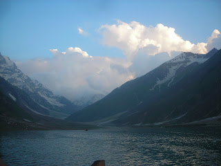
Lake Saif-ul-Muluk is undoubtedly one of the most scenic lakes of the World. Located at about 30 minute distance from Naran in Kaghan Valley, it is a crystal clear bowl of green water at a height of approximately 10,578 Feet above mean sea level.
It is strikingly beautiful and captures the eyes of the tourists. The effect seems to be magical in every sense of the word.
How to get to Lake Saif-ul-Muluk?
From Balakot, you have to travel North towards the small town of Naran, which in fact is one of the largest towns in Kaghan Valley and the main tourist stop during your trip to Kaghan Valley. Naran is about 90 kms from Balakot or 2.5 hours of drive on car.
After crossing (or in literary terms - Climbing, because the bazaar is all up-hill) Naran Bazaar, you will find a bridge over a narrow stream of water. This water in coming from Lake Saif-ul-Muluk, and the track moving along the stream will guide you to the lake itself.
Although you can reach Naran on your personal car, but trip from naran to Lake Saif-ul-Muluk must not be attempted on it. It is highly recommended that a 4x4 Jeep should hired from Naran till the lake, which is hardly a 35-45 minute journey. The track is small and bumpy and a trained driver will take you up without much hassle. You can hire a jeep from Naran Bazaar or the bridge at the end of the bazaar.
A sunset at Lake Saif-ul-Muluk is an unforgettable experience and if you are fond of camping, then Lake Saif-ul-Muluk is one place you will never like to miss. The only guest room available on the lake-side belongs to the Forest Department of Khyber Pakhtunkhawa Province and you can get it booked from their office in Peshawar, if you are so keen at spending a night there.
There are many famous stories about Lake Saif-ul-Muluk and one of them narrates that fairies come to take bath in this lake during the full-moon nights. I can not comment on the authenticity of these stories, but you will have to spend a night there to find out for yourself - How true are these stories?
Lake Saif-ul-Muluk is an unmissable tourist attraction in Kaghan Valley and any tourist travelling in the valley can not even think of missing it.
I have the honor of watching this lake in different times of the year, starting from March to December and the lake has different colors in every month, yet every color is more beautiful than the others. I have seen it frozen in early March as well.
Have you visited Lake Saif-ul-Muluk and how did you find it? Feel free to share your experience below in Comments Section!

Wednesday, October 5, 2011

Pakistan's Best Heritage Site: Lahore Fort

One of my all-time favorite UNESCO World Cultural Heritage Site in Pakistan is Lahore Fort. I absolutely adore the grandeur and splendor of Alamgiri Gate of Lahore Fort.
Lately during one of my recent visits to Lahore, I stole a few minutes while travelling on GT Road to capture some images of Lahore Fort, that I promised to send to a friend abroad. Since I did not have much time at hand, so while I was entering Lahore on a family trip, I just parked my car in the parking lot, brought ice cream for kids and went inside to take the photos.
It was a long time since I visited this place but I found it as magical and attractive as ever before.
Lahore Fort and Badshahi Mosque face each other and offer a great heritage tour, if someone plans to visit there. Where else can you find so many historical places in near vicinity to each other?
Although "Lahore Fort & Shalamar Gardens" is included in the list of UNESCO World Heritage Sites in Danger, but still Lahore Fort is a huge fort with a lot of historical buildings, monuments and gardens. Badshahi Mosque has a magnificent museum depicting various items of Muslim history. Between these two mammoth structures lies the Bara-Dari (Building with 12 doors), that you can see in the above picture as well.
Minar-e-Pakistan (Minaret of Pakistan) is also located across the road, which is a modern architecture building. It was constructed to commemorate the passage of Pakistan Resolution on 23 March 1940.
I will get some more photos to share with you as soon as I visit the place again - which I am anxiously waiting as well.

Friday, April 8, 2011

Minar-e-Pakistan in Lahore - A Symbol of Pakistan's Sovereignty

"Minar-e-Pakistan" or the "Minaret of Pakistan" is a monument built to remember the passing of a resolution to demand a separate country for Muslims of India by All-India Muslim League at this ground on 23 March 1940. This was the first official declaration to establish a separate homeland for the Muslims living in the South Asia. Pakistan now celebrates this day as a national holiday each year.

The minaret reflects a blend of Mughal and modern architecture and attracts visitors from all over the World. The large public space around the monument is commonly used for political and public meetings, whereas Iqbal Park area is popular for kite-flying as well.
Design.   The foundation stone was laid on March 23, 1960. The construction took eight years and was completed in 1968. Today, the minaret provides a panoramic view to visitors who can climb up the stairs or through an elevator. The parks around the monument include marble fountains and an artificial lake.

Structure.   The base is about 8 meters above the ground. The tower rises about 60 meters on the base, thus the total height of minaret is about 72 meters above the ground. The unfolding petals of the flower-like base are 9 meters high. The diameter of the tower is about 97.5 meters (320 feet). The base platform is shaped like a five-pointed star and encloses two crescent shaped pools. There is a central spiral staircase rising up with 162 steps. The top-dome of the minaret is made of Stainless steel inlaid with fine glass pieces.
The structure is made of reinforced concrete, stones, and marble. The rostrum is built of patterned tiles, and faces the Badshahi Mosque. The base comprises four platforms. To symbolise humble beginnings of the freedom struggle, first platform is built with uncut Taxila stones, second platform is made of hammer-dressed stones, whereas third platform is of chiselled stones. Polished white marble at the fourth and final platform depicts the success of the Pakistan Movement.
Inscriptions.   At the base, there are floral inscriptions on ten converging white marble Commemorative plaques. The incriptions include the text of Lahore Resolution in Urdu, Bengali and English, and Delhi Resolution’s text, which was passed on April 9, 1946. On different plaques, Quranic verses and 99 attributes of God are inscribed in Arabic calligraphy, whereas National Anthem of Pakistan in Urdu and Bengali, excerpts from the speeches of Muhammad Ali Jinnah, in Urdu, Bengali and English, as well as few couplets of Allama Iqbal are inscribed.
Minar-e-Pakistan has also been featured on numerous bank notes and coins of the country.
Would you like to visit Minar-e-Pakistan? What are your views for this majestic structure? 


Tuesday, November 2, 2010

Buy Sony PSP from Pakistan Easily

PSP (PlayStation Portable) lets you access games, videos, music and photos at any time and share them with friends. A stylish device, the new PSP system features a TV-out socket for displaying content on a television.
Now you can also buy Sony PSP while inside Pakistan. You can go to www.shophive.com and get your beautiful Sony PSP and they will deliver it directly to your home.
Have you got yours?

Saturday, July 3, 2010

Shandur Polo Festival at HIGHEST POLO GROUND of the WORLD in Pakistan

As Shandur Polo Festival is about to start in a couple of days, so I thought to give it some rightly deserved place on my Pakistan Travel Blog. You can view some of the most beautiful pictures underneath, while you can also see the Beautiful Postage Stamp issued by Pakistan Post here: Shandur Polo Festival Postage Stamp
Historical Polo Match at the Highest Polo Ground of the World is played between the teams of Gilgit and Chitral as the culminating point of the festival and the highlight of the Event.
Military Bands marches at the start of Shandur Polo Festival.
Horses and riders get ready for another exhibition of courage and strength at the Shandur Polo Ground.
Polo gets underway. Riders fight for glory.
Shandur Polo Ground is an absolute beauty at the height of 3,700 meters above mean sea level, which turn out to be a massive 12,650 Feet - Most of the countries DO NOT have a mountain peak of that height ;)
Lovely view of Shandur Free Style Polo

Para Gliding at such a height can also be fun to watch and perform.

Monday, November 9, 2009

Naran from a distance after the 1st Snowfall of Winter 2009 in Naran, Kaghan Valley

Here is a beautiful picture of the sbow-covered Naran Town from a little distance.


Mountains surrounding Naran - All covered with heavy snow!!!

1st Snowfall of Winter 2009 in Naran, Kaghan Valley

Check these cool and exclusive photos of the 1st Snowfall of Winter 2009 in the beautiful town of Naran in Kaghan Valley, Pakistan.
The first photo was taken inside Naran town:


A lot of snow. Isn't it?


You are missing Snow. I can bring some if you want. There is a lot of snow here and not many volunteers to take away ;)

Thursday, October 29, 2009

A "Lovely" Trip to Lulusar Lake in the last week of October 09

A lovely trip to Lulusar Lake is definitely a treat but how about going to Lulusar Lake in the last week of October? Believe me it was still a treat while the mountains were covered in a beautiful white sheet of snow. The road and the mountains around the Lulusar Lake were also white as the fleece of Mary's Little Lamb - I hope that you remember "Mary had a Little Lamb - Its fleece was white as snow" :) So check these cool photos out:

A photo on the road to the magnificent Lulusar Lake:


A photo of the road on the edge of Lulusar Lake - The snow is getting thicker and thicker.


A beautiful view of the gorgeous Lulusar Lake:


Here is another photo of a magnificent view near the lake:

A trip to Babusar Pass in Early Winter Season

I happened to visit Babusar Pass on 23 October 2009. Although the greenery is almost finished, but still the views were absolutely Magnificent. It was chilling cold in the way as well as on the top. Here are a couple of photos of the visit.
The first one is the photo taken from the top of the Babusar Pass and features the view of the valley towards Chillas. The spiral-curling road finds its way down from the top very quickly. It looks just like a spring.


The 2nd one is a lovely photo of snow-covered portion of the Babusar Pass.


Here is a magnificent photo of the vast pastures of Gitidas from Babusar Pass. In the middle you can see the famous Polo Ground which features many Polo games during the summer season. At this point in time, the green pastures have been withered, entire area has been vacated because of the fear of arrival of harsh winter season and the mountains have been covered with white snow. Still the creativity of Allah Almighty can be seen clearly.

Monday, October 5, 2009

Snow at Kaghan Valley

Just a few more pictures of the Kaghan Valley during my cool heli ride. Enjoy!!! Aren't they cool???

The first picture was taken while travelling from Lulusar Lake to Jalkhad. The thick plantation of Pine trees near Jalkhad can be observed in the top left corner of the picture.

Snow is turning slowly in to water in the Kunhar River as we move closer to the famous and beautiful summer getaway town of Naran. Decreasing heights and lesser snow but still many slides on the road.

Houses covered in snow while the inhabitants leave their houses and shift to Balakot or Garhi Habib Ullah before the start of snow fall. They spend their winters in Balakot, Mansehra or Garhi Habib Ullah and move back to Kaghan and other forward areas in spring season along with their animals. Kaghan valley makes a wonderful place for the grazing animals with magnificent and colossal green pastures. I wish I could take my animals from FarmVille there for a season :)


Entering Kaghan Valley from Gilgit on a Flying Machine - Helicopter

A great view of the snow-coated Babusar Pass - A mountainous pass connecting Kaghan or Naran Valley to Indus Valley. The height of Babusar pass is 13,691 feet above mean sea level. While we are flying exactly above the great Babusar Pass, the vast plains of Gitidas can be seen clearly in the below picture. These snow-covered grounds turn in to huge green pastures in summers and serve as the summer homes of hundreds of nomads (Gujjar Tribes) along with feeding thousands of their animals including goats, sheep, cows and horses.

A snow-quilted view of Kaghan Valley near Lulusar Lake. The lake can not be seen at this time of the year as it is completely frozen however those of you who have seen Lulusar Lake thoroughly can clearly see the Northern portion of the lake in base of the white mountains (In almost the top, centre portion of the picture) where a plain white surface can be observed. Yes, you are right, it is not an ice rink but a fully frozen Lulusar Lake. The under-construction road moves along the nullah leading towards Lulusar lake on the left side of the nullah. The twists and curves of the road can also be observed, if seen keenly.

A Helicopter Joy Ride from Gilgit to Naran in Kaghan Valley

A broken bridge between Gilgit and Danyore- A town across Indus river near Gilgit. The bridge on KKH is broken for the last 15 months, I think. I don't know for how long it will remain as such. It is a huge inconvenience to the travelers as they have to cross the river from another bridge after traveling a long distance cross country.
A worth-watching site from the top, isn't it?

An aerial view of Karakoram Highway. A treat to watch from above. I salute those who have laid their lives in construction of this magnificent 9th Wonder of the World.

Colors of nature are so prominent in this snap. Brown mountains, Green patches of trees, Deep-Green River Indus and a cool suspension bridge - What else can you wish to give a treat to your eyes???

Sulphur Springs near Gilgit - Boiling Hot Water coming straight from under the ground

Here are some pictures of "Sulphur Springs" - a beautiful diversity of nature. These springs are located at about two hours drive from Gilgit to Rawalpindi. Due to the presence of Sulphur underground, the water of the springs is hotter than the boiling water. Absolutely hard to touch even!!!

You can even boil an egg by just placing it in the water for some time .......... HOT? Isn't it?

Beautiful Sights While Travelling from Rawalpindi to Gilgit - the Capital of Gilgit Baltistan, Pakistan

Another old but nice-looking suspension bridge on River Indus. Indus is indeed the mightiest of all the Rivers.

Another wonderful view of KKH. Isn't this road leading to heaven? Beautiful snow-covered mountains in the background can give you a feeling of the altitude at which this highway is built.

Check out these Amazing Pictures taken on the Way to Gilgit - The Capital of Gilgit Baltistan, Pakistan

Have you ever seen a river so green. It is the mighty "River Indus"with water coming straight from the melting glaciers and mountain peaks. It is really a beautiful view. Also check the Karakoram Highway running along the river.

A beautiful yellow suspension bridge on the mighty River Indus in front of mountainous background. A lovely sight!!!

A beautiful sight of sloping and flowing Magnificent River Indus where the lovely Karakoram Highway (KKH) moves all along the river.

A bus crossing the land slide. Check a huge bus crossing over the muddy landslide to keep itself on route to its destination. A steep cliff on one side and a sheer fall on the other, but fortune favors the brave only.

What a long line of traveling vehicles struck in the middle of nowhere because of the anger of nature - A landslide.

Related Posts with Thumbnails